Planning and optimizing sales representatives’ routes, step by step
Planning trade routes in SFA/RSE systems. Optimization of travel routes and automation of the entire process. Reach further with your sales
The effectiveness of sales efforts in the field is a result of the price of the product, its promotion, the offer and the relationship developed with the points of sale. Despite the downward trend, the bricks-and-mortar channel remains strong. For this reason, sales visits continue to be one of the most important tools for building relationships with B2B customers. When it comes to making sales visits more effective, good planning of the salesperson’s route is essential.
Every day, thousands of salespeople start their company cars to go out and meet customers. Outside the office, away from the watchful eyes of their superiors, they take to the skies like birds, stretching the ties that bind them to the company to the limit. At the end of the day, they return – in person or in the forms of reports, summaries and e-mails. It is only then that the information about the impact of their work and execution of the strategy reaches the company. The successes and failures of field sales depend on careful planning and quality of execution – inseparable from the geographical dimension. And where territory is concerned, the basic tool – the map – cannot be overlooked.
In this article, we’ll give you some ideas on how the Sales Force Automation system can use the potential of maps and other geographic tools to help sales departments plan and execute field sales activities.
- Sales territory division for sales rep route planning
- Transferring a sales territory to a digital map
- Planning sales routes using maps in the SFA system
- Advanced route optimization
- Planning traders’ routes using maps in the SFA system
- Mobile route optimization for sales reps
- Summary
- Other aspects of territory management – control, reporting and analysis
Sales territory division for sales rep route planning
A sales strategy that include point-of-sale visits is based on good planning. There can be no good plan without taking into account the geography of the sales territory. Whether you want to reach out to existing partners or acquire new customers in the field, there is a number of issues you need to consider when planning sales territories for your sales force:
- Salespeople’s territories should include where they live – daily commuting to work costs fuel, time and manpower
- Territories should be coherent, so that the sum of the distances between visit points is as small as possible (this helps to solve the so-called travelling salesman problem)
- Territories should have clear boundaries to avoid confusion as to which points each salesperson should visit
- Reduce white spots, i.e. the areas that are not assigned to any of the sales representatives (or where there are no specific products), even though they are in the sales territory – especially if there are competitors there
- Avoid imbalances in the number of points or the length of the sales representatives’ routes, especially if they have the same sales targets
- Take into account the location of your own infrastructure and resources (e.g. distribution centres, sub-wholesale, company stores or service points)
- Take into account competitor activity at the point of sale (presence of competing products, price promotions or promotional campaigns)
- Measure the sales potential of your clients and take this into account when planning sales routes (e.g. sales space for your category, ability to place displays, warehouse capacity, number of refrigerators, number of checkout counters, monthly turnover, perfect store score, etc.)
- Collect a variety of data that is both business-relevant and geographically relevant (most of these are store properties, but they can also include segmentation based on regional characteristics such as proximity to the sea or a lake, or proximity to seasonal concentrations of people, the regional presence of certain retail chains).
Transferring the sales territory to the digital map
To a certain extent, geographical analysis is a process that takes place in the real world. However, in order to improve planning and reasoning with the use of maps, it is necessary to transfer the information to the digital environment. The basic process here is known as geocoding, i.e. the assignment of GPS coordinates to all the geographical points that need to be taken into account when planning fieldwork. There are many ready-made databases of geocoded objects on the market, but in many cases it may be necessary for field staff to personally verify and update this data. Sometimes it will be necessary for field representatives to personally verify the accuracy of the assignments. It is important that the databases in all of your systems are consistent in this respect, which is helped by a good data integration.
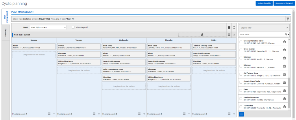
Once the coordinates of the locations have been transferred to the Sales Force Automation application, you can plan your field trips professionally. Using the criteria and knowledge listed above, you can select customers to get a short list of stores to the route. An route is a list of places to visit in a given unit of time, e.g. a day, a week, sometimes a fortnight. Longer planning periods are very rare.
Planning salespeople’s routes using maps in the SFA system
The SFA system helps to arrange the points to be visited so that the route is the most efficient, i.e. contains the maximum number of stores that can be visited in a working day. When planning a salesman’s route, the following information is taken into account: starting point, starting time, travel time (i.e. information typical of navigation tools such as Google Maps or HERE), length of visits, planned breaks or visits at fixed times (e.g. Mr Callum from the Red Arrow deli in Dublin is only available on Tuesdays at 1.30 p.m.). If your sales network is stable and the range of tasks carried out in the field does not change too often, you can safely repeat routes in successive periods and use so-called automatic route planning (which means it is periodical and automatically renewing). However, if you want to remain sensitive to changing market conditions, you need to go one step further.

Advanced route optimisation
Managers who focus on nuanced planning and expect above-average visit efficiency can benefit from advanced sales routes planning and optimisation tools. This is because they are not always the same. These tools automate location selection basing on factors that go beyond driving routes or traffic analysis. Criteria that reflect business potential or sales forecasts, such as route.plus, allow efficient handling of multidimensional databases of information flowing from SFA, ERP or CRM systems.
Planning with maps and geographic tools always saves time. If the planning is accompanied by sound analysis, the results in terms of resource savings and improved business indicators will be seen quickly. It is important to remember, however, that the implementation of these plans should be monitored, for which the use of map-related tools is also worthwhile.
After implementing SFA eLeader, our salesmen’s mileage has been reduced by 10-12 per cent. The eLeader software calculates the most economical route, compares it with the salesman’s actual route and optimises the routes.
Paweł Wrona, Midas
Sales force route planning in a mobile app
Your company may have sales representatives who plan their own work and routes. The SFA mobile application they use should allow them to search for facilities based on valuable criteria, preferably the same criteria used by managers and supervisors to plan routes. An interesting feature is the ability to plan visits on the fly, close to the point to be visited. The radius of the circle in which the proposed customers are located can be defined by the field representative in the app.
The planned route is the starting point for the sales representatives. The engines are already warming up, the asphalt is steaming, the tyres are ready to gobble up the kilometres of the route. The SFA systems are also in full swing, with integrated navigation guiding the sales representatives from one point of sale to the next.
But that’s not all.
Mobile route optimisation for sales reps
Anyone who has worked in the field knows that the ideal scenario is often not possible and that you need to be prepared for changes from the outset. A delayed departure, a traffic jam on the route, a cancelled visit, a longer meeting, an ad hoc visit are just the first incidents that throw a wrench into the original plans.
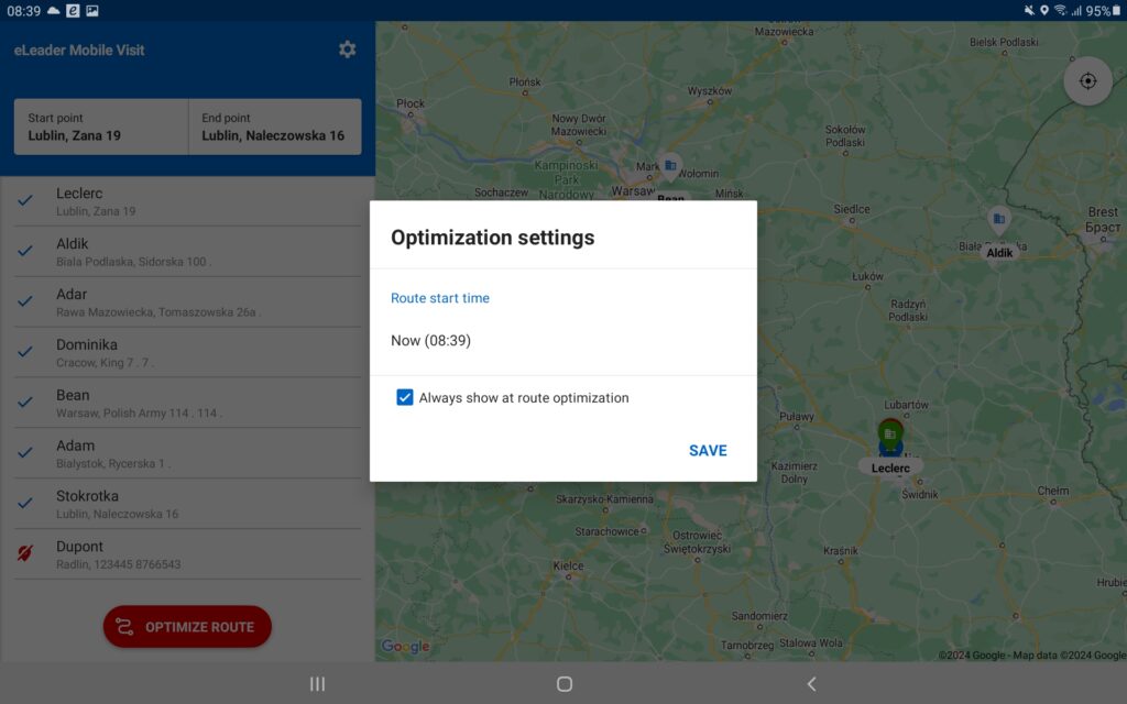
The role of the SFA / RSE application is to reduce the negative consequences of changes that cannot be incorporated into the weekly plan, or even the day before. And while you’re at work, it’s a waste of time to manually search for a new route or point to visit instead of one that has just been removed from the plan. This is where mobile route optimisation comes in, which can be defined as a continuous route optimiser. It is a tool that helps rebuild the work plan, taking into account the day’s schedule and how much time or distance the trader has to drive. The tool is also useful when an unexpected visit needs to be added to the itinerary. It assesses whether such a visit is even possible on a given day, taking into account the location and other waypoints.

SFA’s eLeader Mobile Visit system offers a ‘Deliver Nearby‘ feature that allows a sales visit or other ad hoc activity to be made and added to a day’s schedule without prior planning.
Go further by planning and optimising routes with SFA system
Like a good cake, the effectiveness of field work has many layers and depends to some extent on all of them. The success of a visit depends on whether the representative arrives on time, has enough time and is well-rested to present an offer or to negotiate. They will certainly do a better job if they are not sent to a point on the edge of their territory with almost no chance of completion. SFA systems that support route planning are designed to increase the chances of a good sale. As a tool in the right hands, they can bring tangible benefits to an organisation:
- Sales staff save time travelling to points of sale
- Reduced fuel and running costs of the company’s vehicle fleet
- Work becomes more systematic and predictable
- Route planning is faster and more in line with market realities
- Provides a basis for controlling the execution of plans – both in terms of operational objectives and reliability of work performance
- Enables analysis and optimisation of sales territory management
- Allows you to respond to changes and reduce the impact of negative events during working hours
- Helps to make better use of working time by planning ad hoc visits and optimising routes during the day.
Other aspects of territory management – control, reporting and analysis
One of the core tasks of a sales manager is to plan the routes of the sales force. There are many schools of thought and ways of doing this because the plan has to accommodate different customer contact models and sales process approaches. SFA / RSE class tools have emerged in the world precisely because the need to improve field work planning naturally arises as sales processes evolve.
Another function related to sales territory management is to support the execution of the plan, including the control of route execution and the fraud detection- we write about this in this article . It should also be remembered that even the best plans may not stand up to reality, as they are often simply outdated. That is why it is so important to analyse geographical reports in order to adapt territorial divisions, assignments, routes, tasks or objectives to changing circumstances. In this article you will read how reporting can help sales managers to better understand the current situation and the target market.
We encourage you to try the eLeader Mobile Visit map module and geographical functionality. Our specialists will help you transform your sales territory from terra incognita to the promised land.
Niche knowledge straight to your inbox!
If you find what you’re reading interesting, sign up for our newsletter to receive valuable articles straight to your email inbox.

Leave e-mail here:


